CR Source Water Assessment
The Source Water Assessment was completed to provide information so that the OC-SFWB, NCCWC, and CRW public water system staff/operator, consumers, and community citizens can begin developing strategies to protect the source of their drinking water, and to minimize future public expenditures for drinking water treatment. The assessment was prepared under the requirements and guidelines of the Federal Safe Drinking Water Act (SDWA).
WHAT AREAS ARE INCLUDED IN OC-SFWB, NCCWC, AND CRW’S DRINKING WATER PROTECTION AREA?
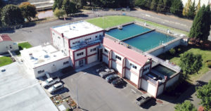
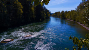
The drinking water for OC-SFWB, NCCWC, and CRW is supplied by three individual intakes on the Clackamas River. These three public water suppliers teamed with DEQ and DHS to complete this Source Water Assessment for the Clackamas River watershed upstream of the intakes. Combined, the three public water systems serve approximately 90,000 citizens.
In addition to the intakes for OC-SFWB, NCCWC, and CRW, there are intakes for three other water providers in the Clackamas River watershed; a schematic diagram of the Clackamas Sub-basin Drinking Water Protection Areas is attached. This assessment addresses the geographic area providing water to OC-SFWB,
NCCWC, and CRW’s intakes (SFWB, NCCWC, and CRW’s portion of the drinking water protection area) between the OC-SFWB intake and the upstream intake for Estacada. The boundaries of the Drinking Water Protection Area are illustrated on the figure attached to this summary. Information on the protection area upstream of the Estacada intake is summarized in SFWB, NCCWC, and CRW’s assessment.
Activities and impacts in the SFWB, NCCWC, and CRW protection area have the potential to also impact the downstream water users (Lake Oswego Municipal Water will be provided a copy of this assessment).
The OC-SFWB, NCCWC, and CRW intakes are located in the Lower Clackamas River Watershed in the Clackamas Sub-Basin of the Willamette Basin. The geographic area providing water to the intakes (the drinking water protection area) extends upstream from the OC-SFWB intake approximately 335 miles (approximately 1,130 miles including area upstream of the Estacada intake) in a southeasterly direction and encompasses a total area of 264 square miles (939 total square miles including the area upstream of the Estacada intake). Included in this area are a number of tributaries to the Clackamas River including Rock, Richardson, Clear, Eagle, Deep, Foster, and Goose Creeks and their tributaries.
The protection area within an 8-hour travel time from the intake extends approximately 14.3 miles upstream of the OC-SFWB intake. It is recommended that the water systems and community consider increased protection within an 8-hour travel time from the intake since eight hours should provide adequate response time to protect the integrity of the public water system intake should a spill or release occur at any crossing or discharge point to the stream.